Factsheet
Flood Facts
- Use caution while returning home after evacuation from a flooding event because water levels could continue to rise even after a major storm has passed.
- Unlike earthquakes, light-frame structures (combustible buildings) are the most vulnerable to flooding.
- Water depth and flow velocity can both have a significant impact on the severity of flooding.
- In a case study of Brick Township, all bridges sustain functional performance during a category 1 hurricane. This finding is in agreement with the observations after Hurricane Sandy, which was less intense than a category 1 hurricane and was categorized as tropical storm.
- In a case study of Brick Township, under hurricanes category 2, 3 and 4, 12.5%, 25% and 38% of the bridges were highly affected.
Flood Mitigation
Ensures structures are able to withstand flooding in their current state and new construction. Examples:
- Adding or increasing “freeboard” requirements (feet above base flood elevation) in the flood damage identified areas.
- Prohibiting first floor enclosures below base flood elevation for all structures in flood damage identified areas.
- Consider orientation of new construction during design.
- Setting the design flood elevation at or above the historical high water mark if it is above the mapped base flood elevation.
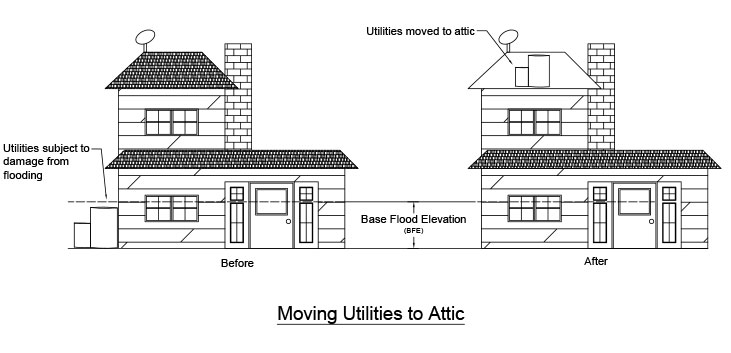
By taking the action to move utilities to higher elevations, such as an attic; typically higher than the base flood elevation level, you are protecting them from the chance of damage due to flooding. Utilities are both expensive to replace and important in everyday use. When recovering from a storm, having functional utilities can increase your recovery rate.
A watertight and waterproof material or sealant, such a plastic, administered to protect water from entering a space. Dry flood proofing is typically seen around the footings of a home or building before a known flooding event to keep flood waters from entering the home either through windows or cracks. Dry flood proofing is normally applied higher than the expected flood level.
In areas that are suspected to flood, flood pumps can remove flood water at large volumes to keep flood waters from rising over a specific depth.
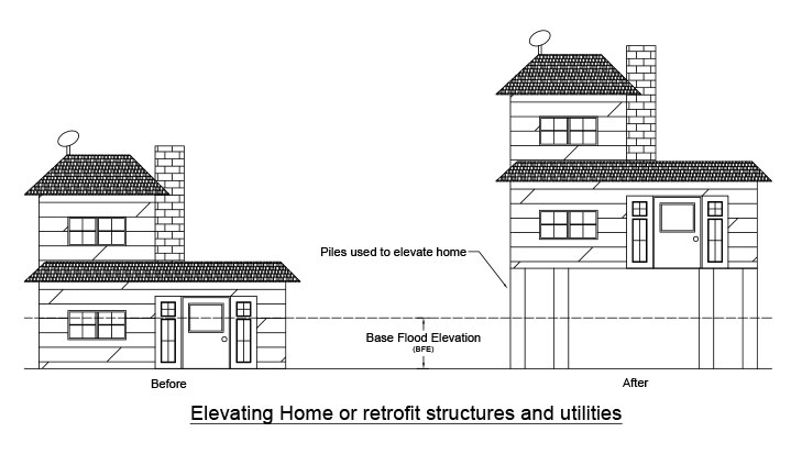
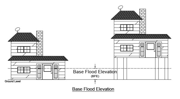
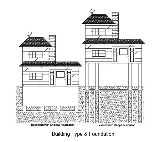
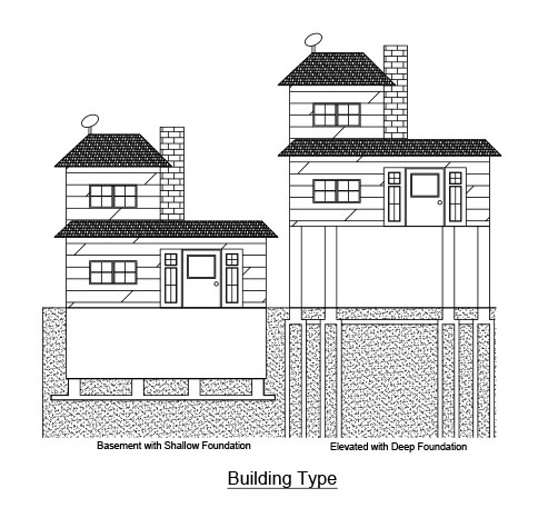
Elevating or raising the structure above the base flood elevation means the lowest living floor space is above the projected water levels. The base flood elevation (BFE) means that elevation or level has a 1 percent chance of being equal to or exceeded by floodwaters in any year. Note that FEMA indicates vulnerable structures should be elevated above the floodwaters associated with a 100-year storm event (1 percent chance of being flooded in any one year) or the "Base Flood." Elevating and anchoring manufactured homes or, preferably, keeping manufactured homes out of the floodplain. Relocating utilities and water heaters above base flood elevation and using tank less water heaters in limited spaces.
Increase the strength of the connection between superstructure and substructure by increasing the number of dowel bars and bolts.
Deep and open foundations (such as pilings) should be used instead of slab-on-grade, shallow and crawlspace foundations.
- Mitigate flooding by influencing hazard conscious development
- Determine and enforce suitable land uses to reduce the risk of damage by limiting exposure in flood zones
- Up to date floodplain and coastal zone management plans
- Mitigating hazards during infrastructure planning.
- Adopting a post-disaster recovery plan
- Passing and enforcing an ordinance that regulates dumping in streams and ditches
- Use of green infrastructure program
- Developing a stormwater committee, regional watershed council, and green teams
Flooding can be mitigated by limiting or restricting development in floodplain areas.
Rainwater, snowmelt, and storm events can cause flooding and erosion. Prepare and adopt a stormwater drainage plan and ordinance. Encouraging the use of Low Impact Development (LID) techniques.
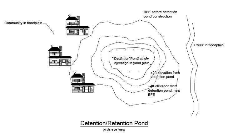
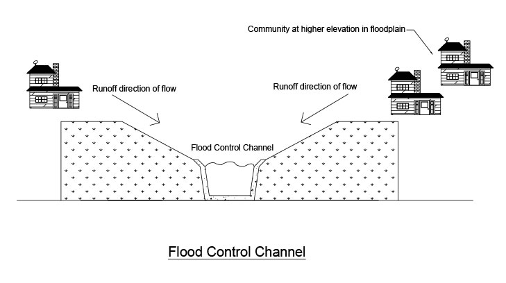
An artificial vertical barrier that is used to contain overflows of water in a certain area during heavy rainfall and large amounts of runoff. The barriers can be used to protect areas that are downhill of large impervious areas by directing the runoff to flow along the barrier to a better location that can handle large amount of water, like a detention/retention pond or a flood control channel.
These are effective to manage stormwater runoff as the deep rooted plants and depressed shape of the garden have the ability to absorb more runoff than grassy or other pervious areas. The depressed shape also allows for water to more easily flow into the garden giving the water a welcomed destination.
Wetlands are essential for naturally retaining surge waters. By maintaining and restoring marshes so that they can attenuate storm surge at their maximum capacity.
Beaches act as a barrier between the ocean and inland areas. Over time, wave action, storm surge, hurricanes, and tidal changes erode beach sand and dunes changing the topography of the beach. Restoring the dunes and adding sand to account for effects of erosion help to sustain the barrier, protecting from surge waters that can lead to flooding.
Natural resources provide floodplain protection and flood mitigation. This includes protecting, creating, preserving, and/or enhancing landforms that serve as natural mitigation features such as riparian buffers, areas of thick vegetation inland, rain gardens, river banks, vegetative beds in stormwater/river channels, wetlands, marshlands, dunes, et cetera.
This includes developing an open space acquisition, reuse, and preservation and land banking plan targeting flood hazard zones.
Conducting cumulative impact analysis and regularly analyzing the size of flood-prone areas. Imposing a through watershed analysis for proposed dam or reservoir projects. Incorporating digital floodplain and topographic data to illustrate flood risk to citizens.
Communities may remove structures from flood-prone areas to minimize future flood losses by acquiring and demolishing or relocating structures from volunteer property owners and preserving lands subject to repetitive flooding/loss.
This provides economic insurance for the personal items for the renters of a property. This low cost solution can be beneficial to those renting in flood prone areas.
Encouraging homeowners to purchase flood insurance, distributing flood protection safety information, educating citizens about safety during flood conditions, including the dangers of driving on flooded roads, and using various types of outreach. This also includes educating property owners about flood mitigation options for properties such as (but not limited to) elevating properties, backflow values, securing debris, moving utilities, and keeping storm drains cleared. Suggest that each household have an emergency kit.
Glossary
| Term | Definition | |
|---|---|---|
100-year flood |
The 1% chance that a flood will occur in a year. However, a 100-year flood can occur multiple times throughout the year. This is normally used as a baseline for design. |
|
ADCIRC |
A system of computer programs for predicting storm surge and flooding, modelling tides and wind driven circulation etc. |
|
Average travel time |
The average time vehicles spent on any specific road or highway to reach from point A (starting) to point B (destination). |
|
Base Flood Elevation (BFE) |
The elevation of water from a flood that is suspected during a given event such as 100-year storm. |
|
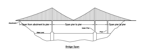
Bridge span |
The distance between two piers or one pier and one abutment of a bridge. |
|
Building age |
The age of a building is used in NJFloodAlert’s model to determine the building codes and rules used at the time of construction for evaluating building functionality and performance. |
|
Building codes |
A set of standards for building and bridge design and construction designated by the government for the protection of consumers and the surrounding environment. |
|
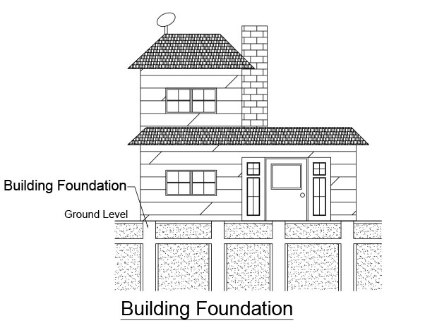
Building foundation |
The component of a structure which connects it to the ground and transfers the structural load to the ground. |
|
Building material |
For NJFloodAlert’s model, the material of a building is considered combustible or noncombustible. A combustible material has the ability to catch fire or ignite where a noncombustible material is fire resistant. An example of combustible material is wood and noncombustible is concrete. |
|
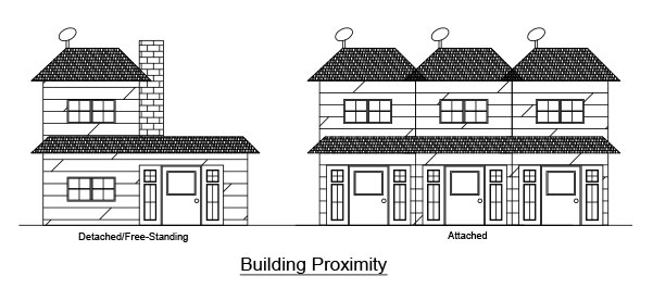
Building proximity |
Whether a building is detached/freestanding (ex. Suburban neighborhoods) or attached/walls connected (ex. Urban areas). |
|
Building type |
For NJFloodAlert’s model, the building type is measured by the lowest floor (basement vs. no basement) and/or the foundation type (elevated vs non-elevated). |
|
Coastal erosion |
The degradation of beaches and cliffs along the coastline due to events such as storm surges, wave impact, flooding, human interaction and sea level rise. |
|
Coastal hazards |
The interactions with infrastructure, natural environment, and communities in a coastal zone that have negative effects in the area such as economic and health losses. |
|
Coastal zone |
Areas, defined along the coastline, which are most likely to be affected by coastal related hazards such as storm inundation, flooding, and sea level rise. |
|
Critical infrastructure |
During an emergency event, facilities that are essential to protection and recovery, such as police stations, hospitals, gas stations, grocery stores, fire stations, etc. This can also include bridges as they provide important evacuation routes. |
|
Detour/alternate route |
A deviation/diversion of traffic movements to avoid a prohibited segment of roadway network. |
|
Digital Elevation Model (DEM) |
A 3D representation of a terrain's surface created from a terrain's elevation data. |
|
Disaster management |
Taking the action to gauge, design, and enforce policies, ideas, and measures that help communities prepare, recover, and adapt to disasters. NJFloodAlert’s model can help communities in disaster management. |
|
Economic component of vulnerability |
Factors including income, home ownership, and residency influence a community's ability to prepare for and respond to hazard events. |
|
Evacuation route |
The state road(s) and highway(s) have been identified by Government Agencies to be utilized during natural calamities/emergencies to transfer people and guide traffic inland to safe zones. |
|
Evacuation speed profile |
The evacuation traffic velocity distribution over time is called speed profile. This distribution represents the variation in vehicle speeds in different conditions. |
|
Federal Emergency Management Agency (FEMA) |
An agency responsible for responding to disaster events such as hurricanes, extreme floods, earthquakes. This agency is a part of the United States Department of Homeland Security. |
|
Flash flooding |
A high velocity large volume of water caused by intense rainfall occurring in minutes with little to no warning. For areas that have little to no pervious surface, flash flooding is more likely. |
|
Flood frequency |
Chance that a flood event will occur in a given period of time (i.e., 100-year flood). |
|
Flood inundation mapping |
A model used to identify areas that are susceptible to flooding based off of storm intensity, flood velocity, elevation and topography of area. Flood inundation mapping is also used to model the interactions between the flood event and the environment which they inundate. |
|
Flood zone |
During a specific flood event, such as a 100-year storm, the area in which is suspected to be flooded. |
|
Footing |
Shallow foundations that are embedded into soil for a short depth. |
|
Functionality |
The ability of a structure to maintain its intended performance. |
|
HAZUS |
A computer model used to predict the potential losses from earthquakes, floods and hurricanes. |
|
Hydrodynamic |
The forces of moving water. An example of a hydrodynamic force is the impact of wave action. |
|
Hydrostatic |
The forces of stationary water. An example of a hydrostatic force is the force exerted by lagoon water on docks. |
|
IDRuM Tool |
A web-based application developed by Delaware Valley Regional Planning Commission (DVRPC) and Pennsylvania Department of Transportation (Penn DOT) to provide detour routes/maps for traffic management during emergency circumstances. |
|
Index |
An index is a quantitative measurement to measure various interacting characteristics in an easily interpretable scale. |
|
Land use/land cover |
Land cover data shows how much of a region is covered by forests, wetlands, impervious surfaces, agriculture, and other land and water types. Land use shows how people use the landscape whether for development, conservation, or mixed uses. |
|
LiDAR |
Laser Imaging Detection and Ranging used to measure elevation with high resolution. LiDAR is used alongside cameras on devices such as drones and aircraft. |
|
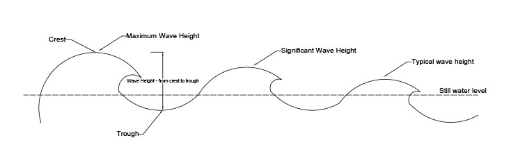
Maximum wave height |
Maximum probable wave height during a hurricane event. |
|
Mean sea level |
Over a designated period of time, the average level of the sea measured from an arbitrary, but common, datum. Common time periods include, monthly, annually, and a 19-year tide cycle. |
|
Natural component of vulnerability |
Characteristics of the natural and built environment, such as percent impervious surface, effect on a community's exposure to extreme hazards events. |
|
North American Vertical Datum (NAVD88) |
The common datum currently used as a reference for measurements such as BFE and SLR. |
|
Nuisance flooding |
A minor flood event, which occurs during high tide. Because nuisance floods are dependent on the tides, they can occur during sunny days and tend to recur during the high tide cycle. |
|
Probability of Failure |
Likelihood of structural demand exceeding structural capacity under a certain limit state. |
|
PTV Vissim |
A traffic flow simulation software allowing the modeling traffic patterns at a microscopic level. |
|
Rapidity |
The rate a building returns to its original functionality from damage. The time it takes to receive funding and construction repairs are included in the rate. This is used to measure to help measure resilience. |
|
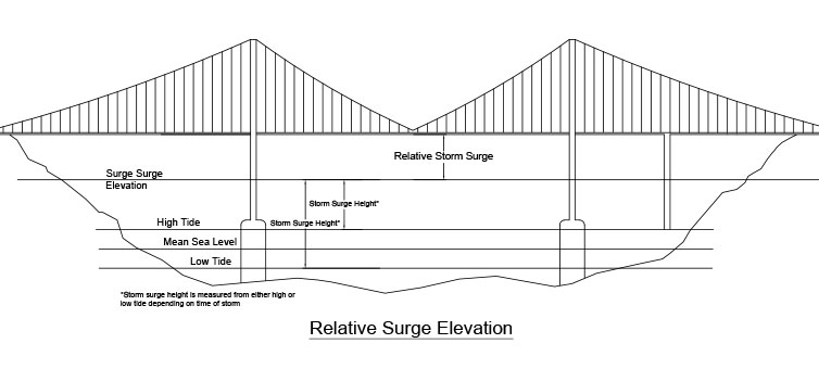
Relative surge elevation |
Vertical distance from bottom of the bridge superstructure cross-section to the storm water level (positive if storm water level is below the bottom of the super structure cross-section). |
|
Resilience Index |
An index quantifying the ability of a structure to maintain the strength and functionality after a storm event and its rapidity to restore. |
|
Robustness |
The ability of a structure to maintain its strength and functionality. |
|
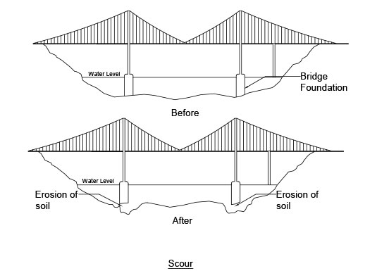
Scour |
The process of erosion of the soil around the foundations of the structures during storm surge and flood events. |
|
Sea Level Rise (SLR) |
The rise of global mean sea level measured from a datum. The sea level can be affected by the changing lands caused by erosion, water volume increase do to melting ice, and other environmental factors. |
|
Significant wave height |
Significant wave height is defined as the average height of the highest one-third waves in a wave spectrum. This happens to correlate very well with the wave height a skilled observer perceives in a wave spectrum. |
|
Social component of vulnerability |
Characteristics of the community, such as age, demographics, and language, influence the ability of community members to recover from extreme hazards. |
|
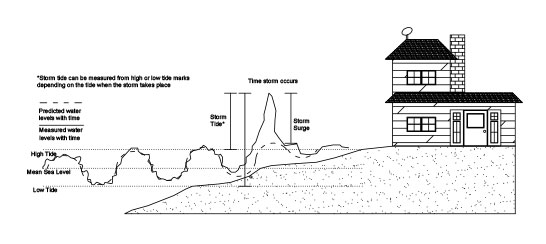
Storm surge |
This is the rising of the sea caused by a storm event. Flooding occurs from storm surges when the surge rises above land elevation. |
|
Structural capacity |
Strength of a structure against a certain limit state. |
|
Structural demand |
The limit state at which hurricane induced forces tend to fail a structure. |
|
Structural limit states |
Different ways that a structure may fail. |
|
Traffic bottleneck |
The impediment/disruption of traffic free flow occurs due to specific physical circumstance, is called traffic bottleneck. |
|
TUFLOW |
A hydraulic model used to simulate flood inundation due to various storm events. |
|
Vulnerability Index |
This is a numerical measurement of the vulnerability of a community to a storm event, incorporating social, economic, natural, and structural factors. The index is measured on a scale from 0-1 where 0 is the least vulnerable and 1 is the most vulnerable. |
|
“What-if” conditions |
Multiple evacuation scenarios developed to evacuate people under different category hurricanes, i.e. hurricane category 1, hurricane category 2, etc. |